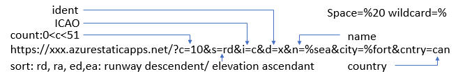
#
ident
ICAO
name
city
country
rwy lnth
srfc
elev
{{ index + 1 }}
{{ apt.ident }}
{{ apt.icao }}
{{ apt.name }}
{{ apt.city }}
{{ apt.country }}
{{ apt.rwy }}
{{ apt.srfc }}
{{ apt.elevation }}
Clear
Plot
Plot airport location with Openlayers WKT / VUE / Azure SWA / X-plane DB. Feb'24. Code
HERE